The web and mobile application offers users exceptionally in-depth information on the one global resource that can no longer be produced — land.
At Inman Connect Las Vegas, July 30-Aug. 1, 2024, the noise and misinformation will be banished, all your big questions will be answered, and new business opportunities will be revealed. Join us.
This article was last updated July 10, 2024.
Land id is a land research and presentation solution.
Platforms: Browser; companion app
Ideal for: Homebuyers, investors, developers, agents
Top selling points:
• Engaging UI/UX
• Property info card design/content
• Simple map layer views
• Site plan overlay/insertion
• Embeddable presentations
• Measurement tools
Initial review: April 2024
Update: July 2024
Top concern(s):
A great-to-have resource when you need it. I fear that it would be too undervalued and that users would neglect what it’s capable of adding to their business, or not understand how it can be applied.
What you should know
Land id couldn’t be more aptly named. (As much as I also love TopHap, in comparison, you should see people’s faces when I recommend it. Topwhat?) The web and mobile application offers users exceptionally in-depth information on the one global resource that can no longer be produced — land. High-level views offer plot lines and ownership labels. Zoom in and access some of the layering options and onboard features, and you’ll find an addicting, informative way to know more about what’s around you than your competition.
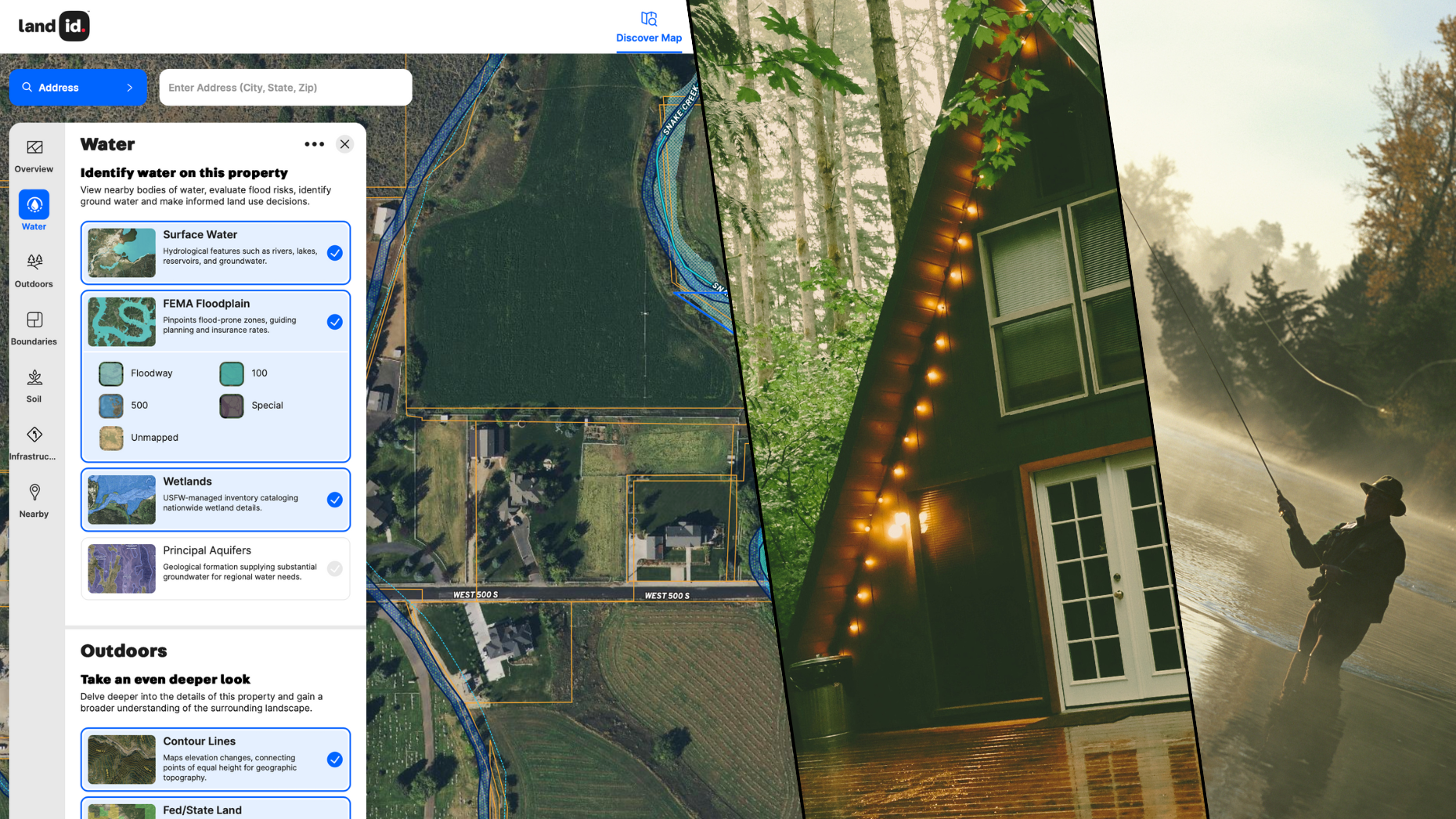
The company is moving quickly to get its product to its best possible version before likely turning its focus inward on strategy and scaling, and in that effort, has already made a big UI (user interface) splash in how the app interacts with the data it presents by overhauling, or perfecting rather, its Property Information Cards.
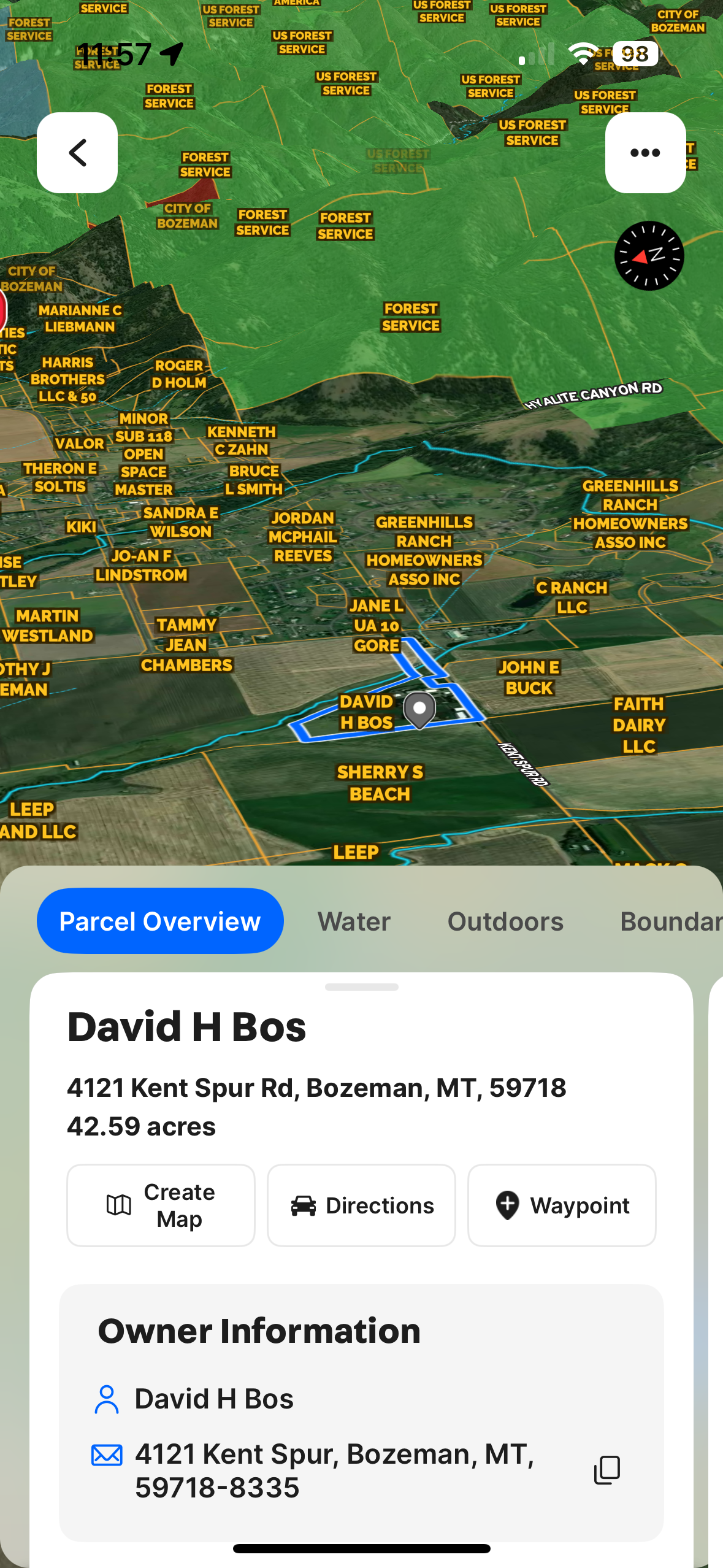
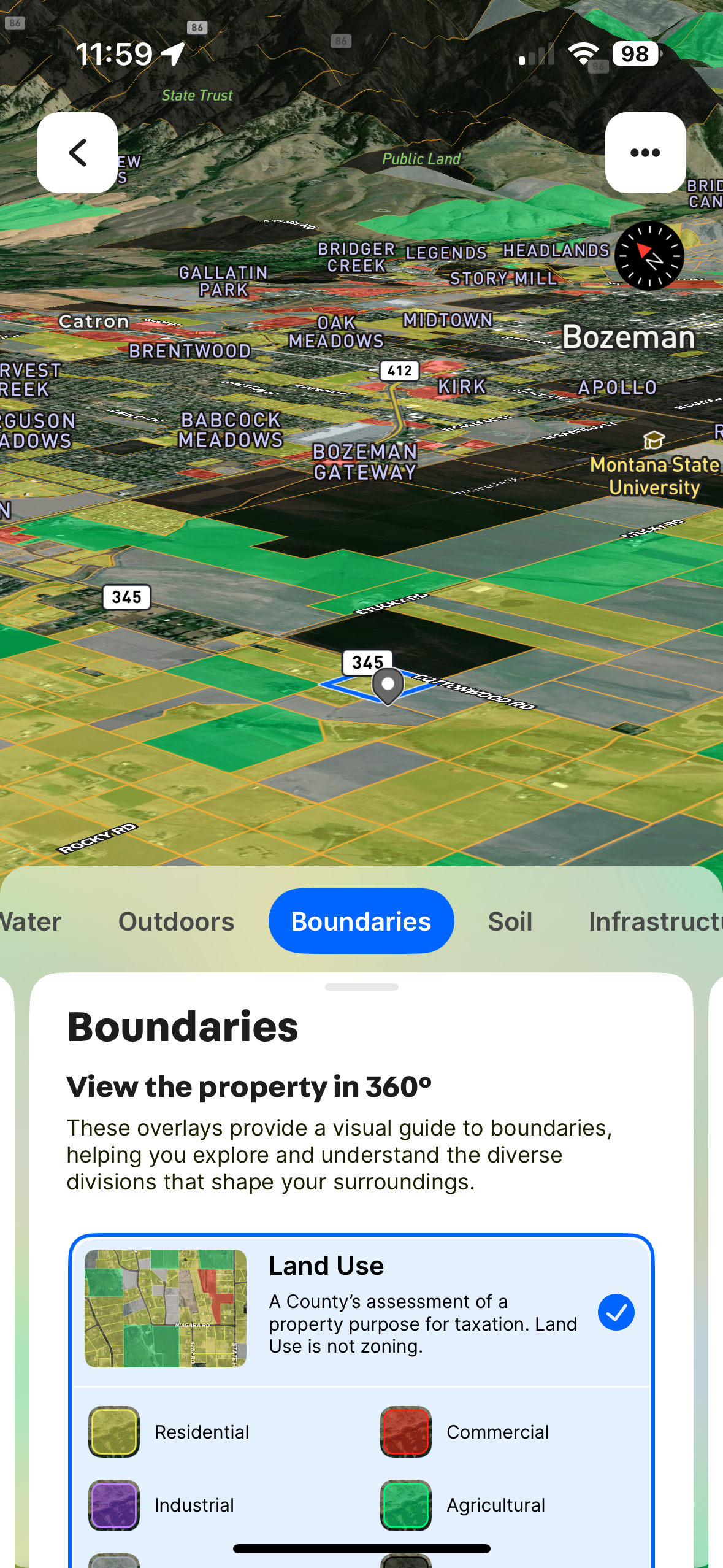
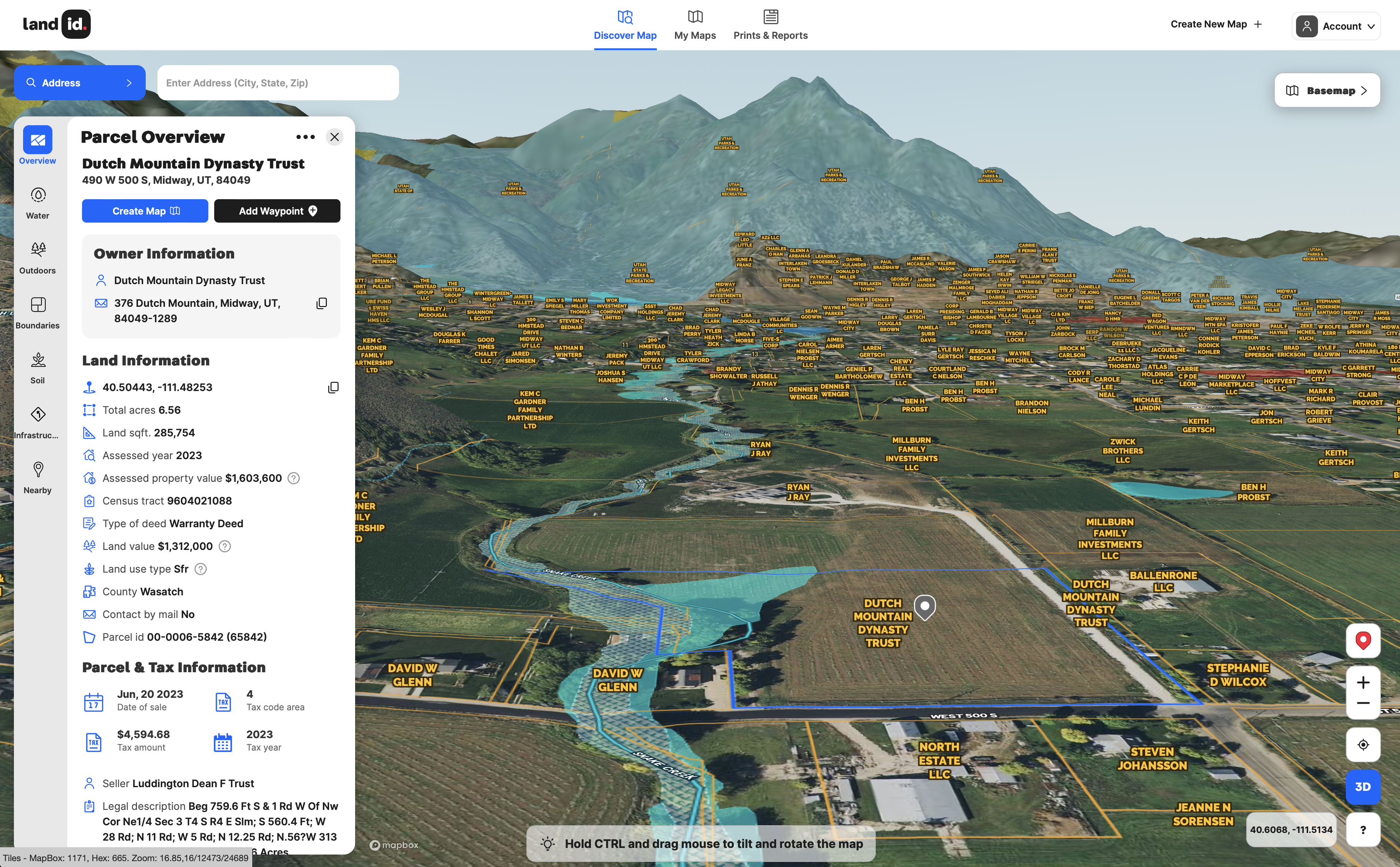
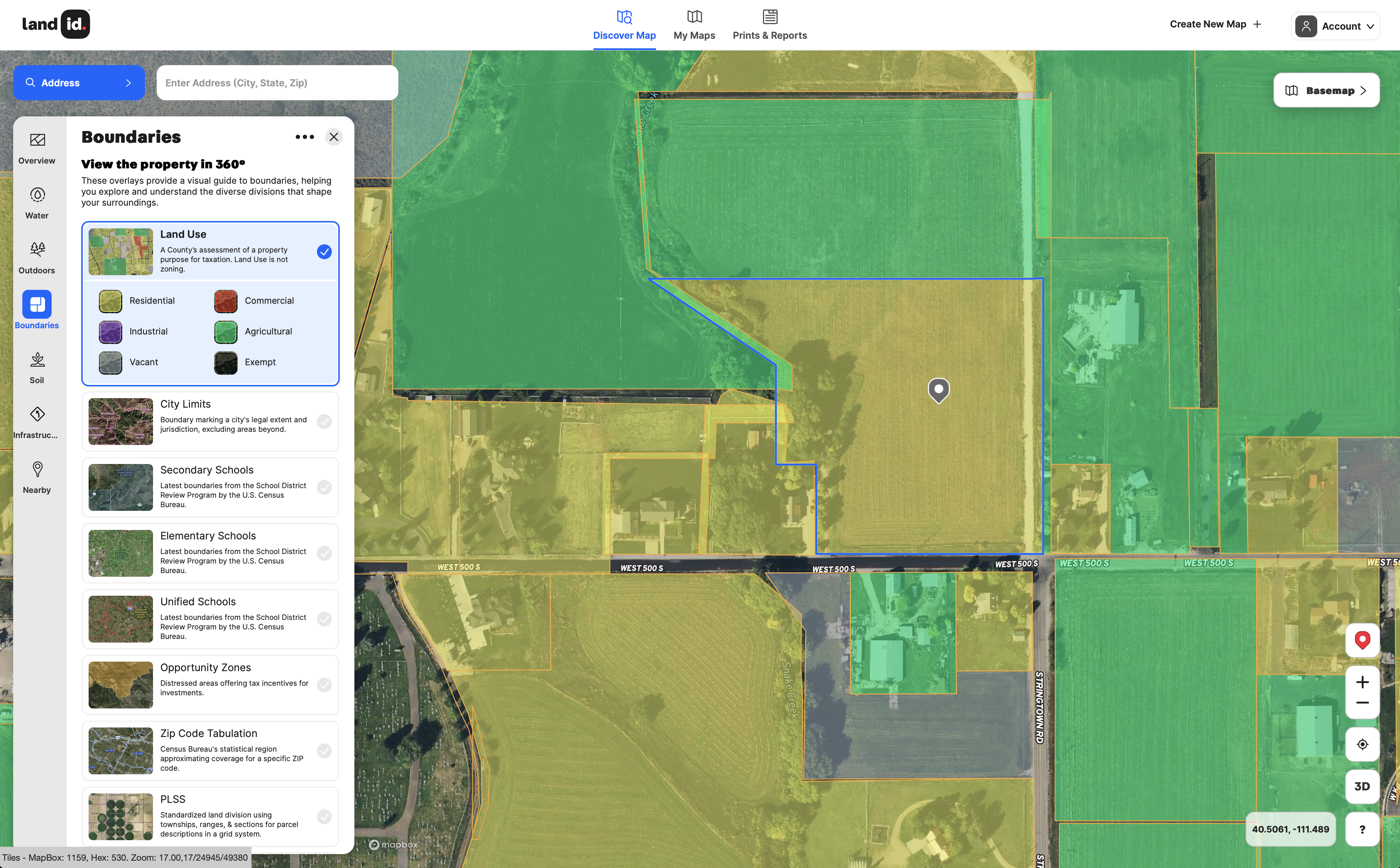
The primary point of engagement for users, the cards can be shuffled through seven primary insights: Overview, Water, Outdoors, Boundaries, Soil, Infrastructure and Nearby. The categorization is contextual, and the prevailing subject map will react with its list of data points as each layer is selected. It’s exceptionally compact and informative, enabling users to learn and share insight quickly.
It’s not easy to present this much information in an engaging mobile experience, and I said as much to the experience designer on our most recent call. While I despise the term, it’s as if Land id has “gamified” the industry’s relationship with land. The app encourages you to keep going, to keep swiping through layers and absorbing what they share.
Everything from font choice to the iconography and title decisions factor into the app’s — any app’s — usability. These choices are all deliberate and become even more justified when used to present critical information, like floodplains, nearby owner information, legal descriptions, owner data and so much more.
Any agent who wants to provide more value than a competitor or who aspires to work with homebuilders can benefit from this application. It renders extensive data visualizations quickly, offers a low learning curve and provides a number of useful marketing presentation features.
A standout feature is the geo-referenced site plan integration. Builders working on a new project, for example, can upload and overlay an image of their site plan drawing on the map and it will snap directly into its correct orientation.
This provides a terrific overview of how a building will interact with what’s around it, enabling stakeholders to adjust ingress or egress if needed, or alter setbacks, for example. It’s also a fantastic way to present publicly a proposed development to a skeptical municipal board, not that they ever have an issue with new developments. Ahem.
Most of us have seen how Matterport (and that’s what this is: Matterport for land.) and iGuide allow you to measure a room from its digital twin. Land id does the same, but for sprawling wooded plots, timber stands or whatever the potential investment.
That’s not data easily verified by hand, in case you’re wondering. You don’t need to hire an aerial photographer, but I imagine a surveyor will still be needed, because “that’s how we always do it.”
Overlays allow the user to click on and off layers of information, such as contour lines for elevation insights, conservation easements (more common in the West), soil reports, city limits, flood zones, school zones, water districts and even grazing allotments, oil wells and game management areas. Maps will default to parcel views, which show who owns what.
For example, I learned that the Hualapai Indian Tribe, a remote native people concentrated in rural northern Arizona along old Route 66, a place I used to spend some time, owns a bunch of acres less than a mile from me outside Lake Tahoe, California. Why? I have no idea, but it’s cool to know.
I also learned what parts of the Truckee River waterline are controlled by the San Francisco Fly Casters Association, the use of which has become problematic for locals. For an agent helping a second homeowner who wants to wet a line, this is valuable stuff to know.
Oh, something else cool? If you’re selling a home by a golf course, Land id can label each hole so a person can select accordingly. Nice touch.
Maps can be viewed in 3D or flat modes or toggled into infrared, vintage topo, modern topo, NAIP (National Agriculture Imagery Program) or hexagonal aerial modes. Users can create and save maps in their accounts, too.
Punching in an address highlights the home or parcel and surfaces a breakdown of pertinent data points, such as lat/long coordinates, land value, acreage, deed type, land use, parcel ID, and sale history with mortgage amounts and tax payment. I did notice that the total value was not accurate, or at least not synced with the market.
Land id has a mobile app with what I was told is 90 percent of the functionality, which is impressive for this kind of presentation power.
I said in my initial review that Land id may not be for the everyday agent. That’s not the case anymore. The more I think about it, the more I realize that in this market, hell, from here on out, the agent that wins is the agent that can provide more unique information than what’s readily available.
If your CMA ends at days on market and median sale price, your days may be numbered. Do more than that; go broader, and offer information that can be strategic, not just tactical. This is why truly knowing a market includes knowing what’s under it.
New agents wanting to understand their community, teams going after developers or agents breaking into new builds would all be wise to get an account. It can only make you better at your job, and that’s what software is supposed to do.
For some existing use cases, check out Wild Flower Ranch and Burgher-Ray Ranch Group.
Have a technology product you would like to discuss? Email Craig Rowe
Craig C. Rowe started in commercial real estate at the dawn of the dot-com boom, helping an array of commercial real estate companies fortify their online presence and analyze internal software decisions. He now helps agents with technology decisions and marketing through reviewing software and tech for Inman.


Comments